Community engagement – October to November 2023
Thank you to everyone who provided feedback on our early design for improvements to Cameron Road from 17th Avenue, through Gate Pā and Greerton Village, to Cheyne Road, Pyes Pā in October- November 2023. You can read the one-page summary of community feedback and/or read the full engagement report below.
One page summary (80kb pdf)
Engagement report (3.2mb pdf)
Select the links below to view the early design information in your area
Tauranga South – 17th Avenue to Twentysecond Avenue | Pukehinahina/Gate Pā – Twentysecond Avenue to Church Street | Gate Pā South – Church Street to Cornwall Street | Greerton – Cornwall Street to Pooles Road | Maarawaewae/Pyes Pā – Pooles Road to Cheyne Road
Cameron Road Stage 2 early design renders (4mb pdf)
Tauranga South – 17th Avenue to Twentysecond Avenue
Key features in the early design for Tauranga South - 17th Avenue to Twentysecond Avenue include:
- Continuation from Cameron Road Stage 1 of the two-way cycleway on the eastern side of Cameron Road.
- Maintain two general traffic lanes southbound between 17th Avenue and Twentieth Avenue.
- Raised crossings (speed tables) for the side streets of Garden Place, Nineteenth Avenue and Twentyfirst Avenue.
- New signalised intersection at Twentieth Avenue to improve access to Tauranga Hospital.
- Northbound and southbound bus lanes (initially peak time operation) to be provided from south of Twentieth Avenue. The southbound bus lane is from Twentieth Avenue and northbound the full length.
- Landscaping/retaining green space between footpath and hospital car park on western side.
- Existing signalised pedestrian crossing south of Twentyfirst Avenue will stay to provide safe access to Gate Pā School.
- Shared path on eastern side of Cameron Road near Twentysecond Avenue intersection to enable safe crossing for pedestrians and cyclists.
- A flexi zone between Twentieth Avenue and Twentysecond Avenue. This allows for additional planting areas, rain gardens, wider footpaths, street furniture, or could be used for on-street carparking. The function will be determined through detailed design in consultation with the community.
- Several areas have been identified as suitable for rain gardens that will assist with stormwater treatment.
You can view the proposed changes in the image below:
Tauranga South map (3mb pdf)
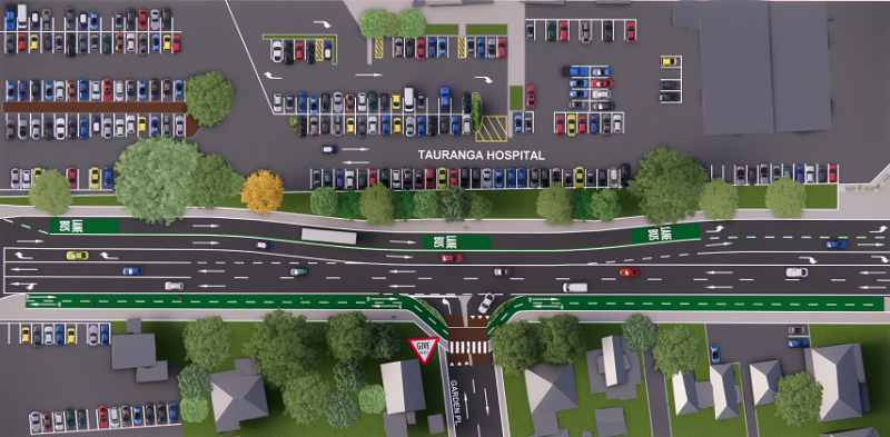
Outside Tauranga Hospital near Garden Place
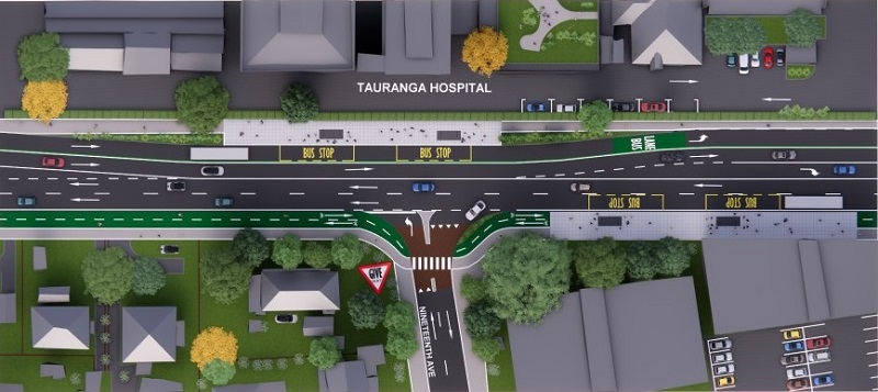
Outside Tauranga Hospital near Nineteenth Avenue
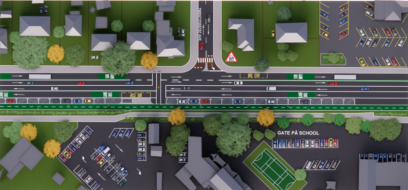
Near Gate Pā School
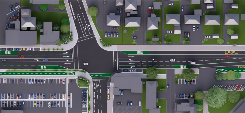
22nd/23rd Avenue intersection
Pukehinahina/Gate Pā – Twentysecond Avenue to Church Street
Key features in the early design for Pukehinahina/Gate Pā – Twentysecond Avenue to Church Street include:
- Two-way cycleway on the eastern side of Cameron Road.
- Northbound and southbound bus lanes (initially peak time operation).
- Maintain a single general traffic lane in each direction and enable full turning lanes at signalised intersections.
- Cameron Road and Munro Street signalised intersection to be upgraded to allow space for the new bus lanes and two-way cycleway.
- Kauri Street converted into a cul-de-sac to reduce the number of side road intersections with Cameron Road. This will improve safety and minimise conflicts between drivers, cyclists and pedestrians. Alternative access can be gained via Rimu Street and Twentythird Avenue. Converting Kauri Street into a cul-de-sac will discourage people from using the residential street as a short-cut. These changes will support quieter, more liveable neighbourhoods.
- A flexi zone on both sides of Cameron Road from Twentysecond Avenue to Mitre 10 MEGA. This allows for additional planting areas, rain gardens, wider footpaths, street furniture or could be used for on-street carparking. The function will be determined through detailed design in consultation with the community.
- A shared path for both cyclists and pedestrians on the eastern side of Cameron Road from Mitre 10 MEGA to Church Street. Buses will merge with general traffic as there is no designated bus lane through this section.
- A new community space alongside the Pukehinahina/Gate Pā site. This space will align to the cultural markers identified in the Urban Design Framework to tell the story of Pukehinahina/Gate Pā. Consultation will be undertaken during detailed design with hapū and the community to determine the design.
- Signalised pedestrian crossing added next to the tennis courts to provide access to the proposed cultural centre and provide a connection to Kopurererua Valley walkway.
- Cameron Road and Church Street intersection to be signalised to allow for better access, safer crossing and to enable bus priority.
You can view the proposed changes in the image below:
Pukehinahina/Gate Pā map (2mb pdf)
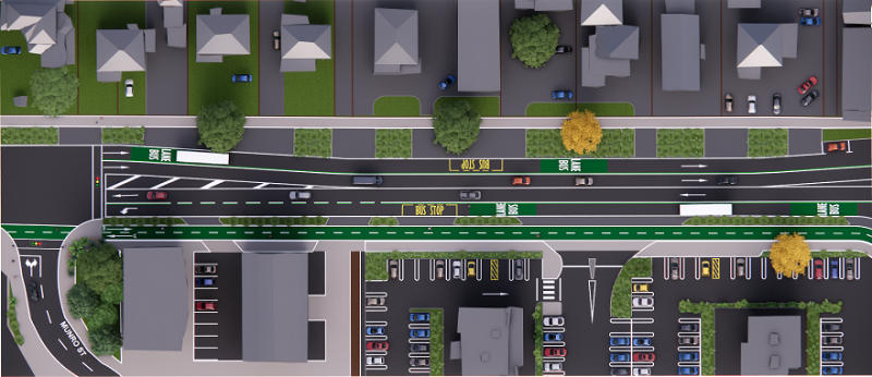
Munro Street/Outside Gate Pā Shopping Centre
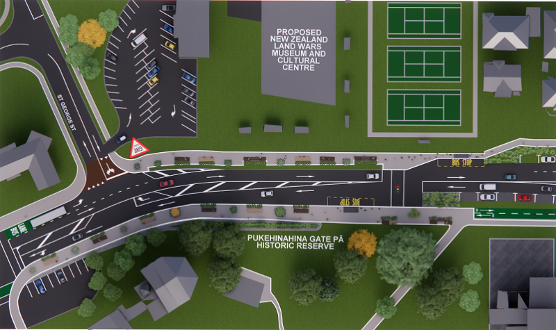
Outside Pukehinahina/Gate Pā Historic Reserve
Gate Pā South – Church Street to Cornwall Street
Key features in the early design for Gate Pā South – Church Street to Cornwall Street include:
- Two-way cycleway on the eastern side of Cameron Road.
- Northbound and southbound bus lanes (initially peak time operation).
- Maintain a single general traffic lane in each direction.
- Signalised pedestrian crossing near 1150 Cameron Road (currently a pedestrian refuge island).
- Rain gardens designed to manage stormwater runoff for the eastern side of the road between Church Street and 1210 Cameron Road (further detail to be added as part of the detailed design phase).
- Sheppard Street will be converted into a cul-de-sac to reduce the number of side road intersections with Cameron Road. Sheppard Street has been selected because alternative access to Cameron Road is available via Greerton Road and Church Street or Cornwall Street. The Cornwall Street roundabout is proposed to remain in place while the intersection of Cameron Road and Church Street is proposed to be signalised. Converting Sheppard Street into a cul-de-sac will discourage people from using the residential street as a short-cut. These changes will support quieter, more liveable neighbourhoods.
- Kent Street to be upgraded to a signalised intersection with Cameron Road.
- A new community space outside Te Po Roa Reserve. This space will connect Cameron Road to the reserve, acknowledging its heritage. Consultation will be undertaken during detailed design with hapū and the community to determine the design.
- A flexi zone between 1217 and 1235 Cameron Road (western side). This allows for additional planting areas, rain gardens, wider footpaths, street furniture, or could be used for on-street carparking. The function will be determined through detailed design in consultation with the community.
You can view the proposed changes in the image below:
Gate Pā South map (1mb pdf)
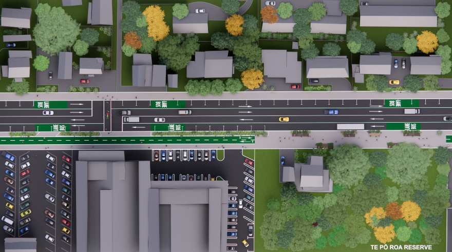
Outside Te Po Roa Reserve
Greerton – Cornwall Street to Pooles Road
Key features in the early design for Greerton – Cornwall Street to Pooles Road include:
- Two-way cycleway on the eastern side of the road. The cycleway will then cross Cameron Road at a new signalised, shared pedestrian/cyclist crossing south of Chadwick Road and continue on the western side of the road. This will enable on-street parking outside the shops to be retained.
- The signalised crossing immediately north of Chadwick Road is proposed to be removed. A new zebra crossing is proposed halfway between Cornwall St and Chadwick Rd.
- Maintain a single general traffic lane in each direction.
- No bus lanes in this area. Buses will use the general traffic lane through this section.
- The existing bus stops will be retained within Greerton Village.
- A new community space within Greerton Village. This space could be a public plaza located within the existing off-street parking area to support Greerton Village as a gathering place for the local community. Consultation will be undertaken during detailed design with hapū and the community to determine the design.
- Pooles Road and Cameron Road intersection to be signalised (removal of existing roundabout).
- No plans to remove any trees or parking on the western side.
You can view the proposed changes in the image below:
Greerton map (3mb pdf)
Maarawaewae/Pyes Pā – Pooles Road to Cheyne Road
Key features in the early design for Maarawaewae/Pyes Pā – Pooles Road to Cheyne Road include:
- Two-way cycleway on the western side of Cameron Road.
- Maintain a single general traffic lane in each direction.
- Northbound and southbound bus lane (initially peak time operation)
- Oban Road and Cameron Road, and Maleme Street and Cameron Road intersections to be signalised.
- Existing mid-block signalised crossing outside Greenpark School to remain.
Additional work will be carried out during the detailed design phase to connect the upgrades with future improvements planned by Waka Kotahi as part of the Tauriko Network Plan, including an upgrade of the SH29A Barkes Corner intersection. See a map of the preferred option for these improvements. The preferred option includes delivering the works in four stages and the Barkes Corner improvements are part of Stage 3, indicatively scheduled for 2026/27 to 2030/31, subject to funding.
Subject to the future improvements planned by Waka Kotahi at the SH29A Barkes Corner intersection, this project proposes:
- Upgraded footpaths both sides of Pyes Pā Road from Havenbrook Way to Cheyne Road.
- Northbound and southbound bus lane (initially peak time operation) on Pyes Pā Road from Havenbrook Way to Cheyne Road.
- Signalised intersection at Cheyne Road.
You can view the proposed changes in the image below:
Maarawaewae/Pyes Pā map (3mb pdf)
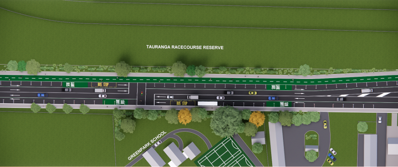
Outside Greenpark School