× Search

Te Tumu: Structure planning

Te Tumu: Mahere Tūāhanga

Te Tumu: Structure planning

Structure planning will help to identify the opportunities and constraints around potential future development within Te Tumu. This process will help inform the key issues to be addressed as part of a potential change to the City Plan.

What is structure planning?

Structure planning is a way of planning for new urban areas that looks at the bigger picture. It considers things like what characteristics an area has and what types of land uses could be sustained. It also looks at options around where and what kinds of buildings could be built and where key infrastructure could go. The goal is to make sure that everything works together and the whole area functions well.

What does structure planning for Te Tumu consist of?

Structure planning for Te Tumu has been underway for several years. It began following the completion of a strategic planning study that considered several key factors and concluded there were no fatal flaws in undertaking structure planning for the area.

Since then, a considerable amount of work has been undertaken to develop a more thorough understanding of the area. This work has included undertaking various assessment work, and discussions with landowners and tangata whenua. Whilst many of these assessments had already been significantly advanced, ongoing changes in national guidelines and policy requires a lot of this work to be revisited and discussions with landowners and tangata whenua will continue.

The assessments completed to date cover a wide range of topics and are captured within multiple technical reports. Assessments cover topics including natural hazards (which also consider the added impact of potential sea level rise), infrastructure, ecological, cultural and landscape factors. Access to the assessment reports can be found by using the links below.

Subject Title Author Date
Active Faults Active fault mapping (1.8mb pdf) GNS Jul-2017
Coastal Hazards Coastal inundation mapping (1.4mb pdf) NIWA Aug-2017
Coastal erosion hazard assessment (4.4mb pdf)
Coastal erosion hazard assessment update (1.2mb pdf)
T+T Mar-2018; May-2020
Tsunami hazard assessment (2.8mb pdf)
Tsunami hazard assessment update (7.1mb pdf)
T+T Mar-2018; May-2020
Liquefaction and Lateral Spread Liquefaction assessment (8mb pdf) T+T Jun-2018
Lateral spread – Conceptual design and risk assessment (3.7mb pdf) T+T Oct-2019
Liquefaction risk assessment for lifeline utility infrastructure (6.2mb pdf) T+T Jul-2020
Contaminated Land Report on preliminary site investigation (9.1mb pdf) Aurecon Oct-2017
Subject Title Author Date
Transportation Te Tumu multi-modal transportation recommendations (12.1mb pdf) MRCagney Sep-2018
Stormwater Te Tumu overflow channel – Design statement (1.3mb pdf) Aurecon Sep-2018
Te Tumu stormwater management strategy (9.2mb pdf) Beca  Nov-2020
Wastewater Te Tumu wastewater structure plan study (4.1mb pdf) Stantec May-2022
Water Te Tumu water supply structure plan study (6.8mb pdf) Stantec Apr-2022
Subject Title Author Date
Archaeology Archaeological assessment report (9.2mb pdf) Bay Arch Jun-2019
Technical Assessments Cultural values literature review (2.3mb pdf) Te Onewa May-2019
Tangata Whenua consultation report (Jul 17 – Oct 19) (1mb pdf) Te Onewa May-2020
Te Tumu significant māori areas review (7mb pdf) Te Onewa Sep-2020
Subject Title Author Date
Open Space and Reserve Planning Reserves and Open Space Action & Investment Plan (2mb pdf) Tauranga City Council Aug-2023
Open Space Level of Service Policy Open Space Level of Service Policy (315kb pdf) Tauranga City Council Dec-2022

Key information

Project type
Major projects
Planning, design and renewal

Status
Planning

Neighbourhood
Papamoa / Papamoa East

Who's listening

City Planning and Growth 
Tauranga City Council

tetumu@tauranga.govt.nz 
07 577 7000

What are these assessments telling us about Te Tumu?

These assessments not only provide more detail on the physical limitations of the land and reconfirm the significant historic and cultural importance of Te Tumu, but also help to understand the land’s capacity to support urban development.

To date, the assessments have identified around 340 hectares of land within Te Tumu would likely be inappropriate for urban land uses due to the proximity to the coast, and other freshwater bodies. These areas would be more suitable to be set aside for the protection and preservation (and in some cases enhancement) of the significant natural, landscape and cultural values they hold.

The remaining area (approximately 400 hectares) does provide an opportunity to enable a range of urban land uses such as residential, commercial and community type activities. These areas would need to be complemented by areas for local reserves (playgrounds, sportsfields), roading networks (supporting a range of active transport modes) and infrastructure, which includes stormwater management areas. Once these areas are considered, the remaining developable area could have the potential to deliver around 6,000 homes over the long term.

This work to date has helped in the preparation of a draft structure plan. This plan is a way of illustrating, at a high level, these areas and how they may link in with the surrounding area.
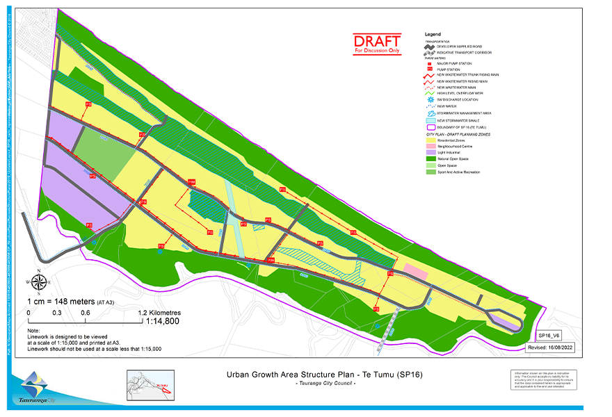
structure plan

Te Tumu Structure Plan (544kb pdf)

Will there be updates to this structure plan?

As noted earlier, many of the assessments that have been undertaken to guide the development of the draft structure plan will need to be updated and reviewed given changing national direction (such as the new National Policy Statements), and as further updates are made to guidance around matters like sea level rise projections. There are also assessments that have not yet been completed.

As this work continues, any changes to the draft structure plan will need to be considered and communicated with project partners.

Other ways to get involved

Tauranga is your city. We're working to make it even better.

Tauranga City Council, Private Bag 12022, Tauranga, 3143, New Zealand |Terms of use|Privacy statement

Back To Top